Project workshops
This workshop conference is focussed around our core projects which will be presented, discussed, and worked on in a fully interactive session. We intend that this workshop conference will do more than disseminate knowledge - it will be used to generate new ideas, develop ongoing projects, and create real outputs including guidelines and research direction.
Our core project workshops are listed below. We welcome offers from delegates to be involved in organising these workshops, or proposing additional workshops.
 Funded for five years by MBIE’s Endeavor Fund, this programme aims to move away from expensive local reactive (post-event) in-situ monitoring to pro-active (pre-event) space-based observation across all Aotearoa.
Led by GNS Science, this work will be in collaboration with NIWA, University of Waikato, University of Canterbury, University of Leeds (UK), University of Oregon (US), University of California (US), University of Washington (US) and the Disaster Prevention Research Institute, Kyoto University (Japan).
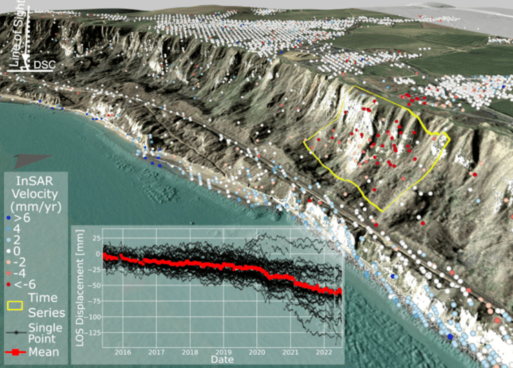
While the Sliding Lands work pays most attention to rapid, first-time slope failures that create obvious scars in the landscape and have immediate consequences, this second programme focuses on a slightly different hazard. Many landslides are pre-existing, large, deep, slow-moving and persist for generations; they damage homes, infrastructure and sometimes accelerate to fail catastrophically. Forecasting when a landslide might transition from slow to fast depends on our ability to identify the movement, constrain its mechanism, and model that movement under different driving conditions.
Until now, methods used to find and predict the occurrence of damaging landslides faced considerable limitations, with traditional ground-based monitoring being too costly, time-consuming, and offering limited spatial coverage. The team propose to use satellite data (InSAR) to detect slow-moving landslides, link their movement patterns to the climatic drivers and characterise their behaviour before they cause damaging and/or catastrophic impacts.
This ambitious approach will enable landslides to be identified nationwide, link their movement patterns to climatic drivers, and characterise their behaviour before they cause damage.
Background information is available here:
This workshop will be led by Chris Massey and Ian Hamling to discuss emerging remote sensing techniques and advanced modelling approaches to link these to potential landslides, and to consider how best international practice can be applied to the Landslide Watch NZ project.
 The 2007 AGS Landslide Risk Management guidelines are being updated by an international panel. The guidelines aim to provide geotechnical practitioners, land managers, asset managers and regulators with a state of the art, internationally respected, clear and concise guidance to identify, assess and mitigate landslide hazards. While the focus is on use in Australia and New Zealand, they are expected to be useful globally.
The updated documents should be 90% complete by April 2026.
Background information is available here:
The workshop, led by Darren Paul and Anthony Miner, will solicit feedback on the documents from experts around the world which will be used to finalise the document. Case studies will be presented, and assessed using a variety of approaches from around the world to identify international differences and opportunities for improvements.
The Hōretireti Whenua Sliding Lands programme will create national-scale landslide models that can forecast where rapid and dangerous landslides are likely to be triggered by earthquakes and rainfall events.
This five-year research programme is funded $10.5 million from the MBIE 2023 Endeavour Fund and is led by GNS Science, with research partners Massey University, Manaaki Whenua Landcare Research, Te Runanganui o Ngāti Porou, Market Economics, University of Auckland, Resilient Organisations and University of Canterbury.
GNS Science is working with iwi partners, international collaborators from the UK (Durham University) and Switzerland (ETH Zurich) and stakeholders from central and local government.
The models will use susceptibility factors such as rainfall, ground shaking, vegetation type, and slope gradient to determine the likelihood and locations of fast-moving landslides across the country for earthquake and rainfall triggers. These susceptibility models will be combined with landslide runout models and vulnerability models to predict the hazard and risk from landslides. From this information our models will determine what the impacts may be, particularly to people, property, industry, and the environment.
The programme will also investigate people’s perception of landslide phenomena, hazards, and the models we develop to understand the risk and impacts of landslides, as well as their perceptions of vulnerability to landslides. Findings will be used to improve the communication and visualisation of model outputs around risk, as well as inform the development of the models themselves.
The effectiveness of the landslide models will be tested and refined using two case studies based in Tairāwhiti and Auckland.
Background information is available here:
This workshop, led by Saskia de Vilder and Emma Hudson-Doyle, will compare lessons from related projects around the world to identify common lessons and overlaps.
LEARNZ is a programme of free virtual field trips, helping students access the inaccessible and visit inspiring places around Aotearoa, Antarctica and beyond.
This workshop, led by the LEARNZ team, will record a series of interviews with delegates as part of our field trips in interesting landslide locations. It aims to raise awareness with intermediate school children, and to introduce them to geoscience as a profession.
You can see an example of how our results will look below, or find out more on the LEARNZ website.
For the rest of the series of field trip videos about the Alpine Fault, see the LEARNZ Course 203. This is just one of many spectacular resources made available free of charge for school students.
We also aim to have smaller sessions focused on:
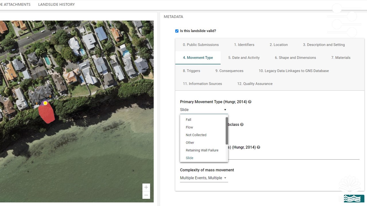 It is accepted that consistent, high quality data is essential for large scale analysis of landslide susceptibility, hazard, risk and loss. The United Nations office for Disaster Risk Reduction (UNDRR) and its partners encourage the development of data standards and methodological frameworks as part of the process to strengthen national capabilities in tracking disaster losses and damages.
This workshop will focus on how traditional approaches to documenting landslides can be adapted to align with modern data standards, to support the UNDRR and others around the world.
UC's Professional Master of Engineering Geology (PMEG) is the only programme of its kind in Australasia. It concentrates on professional training for practitioners. The PMEG is strongly applied and concentrates on professional training for practitioners, delivered in a 12-month format. Having been closed to new enrolments for several years, it is forecast to take its first new intake of students in early 2026.
This conference will help provide a springboard for the field-based elements of the programme, bringing in international expertise to support the team, and has the potential to deliver a significant field-based training programme alongside the conference.
 The New Zealand Geotechnical Society is taking a series of actions to engage with its members and relevant stakeholders to explore issues relating to the availability of a skilled workforce in New Zealand.
The objective is to finalise a position and an action plan for NZGS that will include the different perspectives and to advocate for improvement.
This work will be continuing over the coming years and will use the 2026 landslide conference to share our experiences with an international audience, and to learn from their successes and challenges.
Some of the material published so far as part of this initiative includes: