Training
As a workshop conference, training courses delivered alongside and in parallel with the conference will be a core part of the experience. Confirmed training courses include:
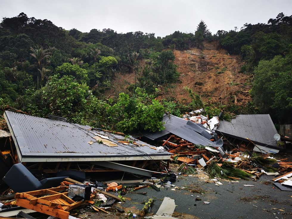
Radar interferometry (InSAR) is a rapidly expanding technique that offers valuable insight into ground deformation for a range of applications, particularly in the field of geotechnics. Due to advancing radar technology and increasing numbers of satellites, the quality and frequency of spaceborne radar coverage available for InSAR is continually improving. An increasing range of radar datasets are becoming freely available, further increasing application potential in geotechnical studies of various scale. However, InSAR is a technically complex technology necessitating appropriate planning, processing, and interpretation.
This course is aimed at providing end-users and those commissioning imagery with a robust understanding of the technique and its limitations in order to improve success and avoid disappointment. Those interested in conducting their own processing using commercially available software require further theoretical and applied background that is beyond the scope of this workshop.
This will be a two-day session presented in advance of the main conference (on Sunday 26 and Monday 27 April). This means you can register for this and other training (which will be on Wed 29 April). Please take this into consideration when planning your travel.
Day 1 - The Basics
Providing high-level understanding of InSAR and its applications for a range of ground deformation questions through key lecture topics. The session will be held in central Hobart starting at 8:30
- Basic introduction to synthetic aperture radar and its differences from remote sensing techniques conventionally used in geotechnical investigations (e.g. aerial photography, optical satellite imagery, LiDAR).
- Overview of various InSAR techniques, their processing chains, and their strengths and weaknesses for particular applications.
- Case studies of InSAR applications for slope stability and ground subsidence including discussion of specific considerations relevant to particular project types (e.g. pit mine stability, ground subsidence, landslide mapping, urban geohazards).
- Merits of outsourcing and in-house processing (e.g. what to ask for when commissioning third party providers; assessing tenders from third party providers; what skill sets and resources are required for in-house processing; what data formats to specify from your provider).
Day 2 - Technicalities of InSAR
Providing greater detail on the processing chain for various InSAR techniques as well as specifics of data selection and access.
This final, lecture-based component of the workshop targets more advanced users including those with interest in conducting their own InSAR processing. Activities and topics will include:
- Defining geotechnical problems in a way your InSAR provider will understand.
- Selecting suitable imagery and satellites in greater detail.
- Processing methods in more detail.
- Advanced quality assessment of delivered products.
Details at a glance
- Presenter(s): Dr. Bernhard Rabus, Dr. Nicholas Roberts, Dr Ian Hamling, Prof Tim Wright, Prof Andy Hooper
- Proposed date: 26-27 April
- Proposed time: 09:00-16:30
- Number of spaces: 30 (minimum 15, refunds available if this isn't achieved)
- Cost: $1,600 NZD
Note that this training is on a different day to the other available training, so it can be booked in addition.
Your presenters
 Dr. Bernhard Rabus is a Professor in the School of Engineering Science, Simon Fraser University, Canada, and their Industrial Research Chair in Synthetic Aperture Radar. He has a geophysics background and is an internationally recognised expert in InSAR technology and processing with numerous academic publications to his credit, plus prior experience in government and industry roles. He teaches graduate and undergraduate courses in synthetic aperture radar applications, including InSAR, and undertakes a range of radar-based research activities. He has delivered many courses on InSAR around the world including in Australasia. His research interests are technologies, techniques and applications of SAR, with a focus on two key areas: (i) Maritime Applications of SAR such as vessel detection and characterization, ocean parameter derivation, and multi-sensor fusion for maritime domain awareness, and (ii) Novel Land Applications for Multi-channel SAR (spaceborne and airborne sensors) using advanced interferometric and polarimetric time series analysis techniques
 Dr. Nicholas Roberts is a natural hazards geologist in the Geological Survey Branch of Mineral Resources Tasmania. He has strong interests in landslides and Quaternary geology with a range of academic publications and previous industry and government roles, specialising in hillslope processes, landscape evolution, and societal risk. Nick is also an Adjunct Professor at Simon Fraser University and collaborates with Dr. Rabus as an end-user to apply InSAR to a range of geological applications in diverse settings, including Tasmania, with a focus on landslide risk. Nick was the lead for a recent 3-day InSAR training course held in Tasmania that was very well received and forms the basis for the 2-day course proposed here.
 Ian Hamling is a geodetic scientist specialising in Satellite Radar Interferometry (InSAR) to measure and model surface deformation associated with tectonic and volcanic processes. After completing his PhD in 2010 at the University of Leeds, UK, and a two-year post-doctoral position at the International Centre for Theoretical Physics in Trieste, Italy, he moved to GNS Science in 2013. Since his arrival, he has worked on broad range of projects ranging from volcanic eruptions and earthquakes to landslides and the effect of vertical land movement on sea level rise. He was the recipient of the 2017 Royal Society of New Zealand Hamilton Prize, is PI for the New Zealand volcano supersite, co-lead of the South-East Asia volcano demonstrator program and co-leads a newly funded Endeavour programme: Landslide Watch Aotearoa which uses InSAR to assess landslide hazard across New Zealand.
 Andy Hooper is Professor of Geodesy and Geophysics at the University of Leeds, UK. In 2016 Andy was awarded the James B. Macelwane medal by the American Geophysical Union, given to outstanding early career scientists who have shown depth, breadth, impact, creativity and novelty in their research, and is co-founder and director of the university spin-out Satsense. He has pioneered the development of new algorithms to accurately extract deformation of the ground from time series of satellite radar images, which are now widely used in the community (StaMPS). He has also developed new methods for modelling the volcanic and tectonic processes that lead to ground deformation.
 Tim Wright has been at the University of Leeds since 2006, initially as a Royal Society University Research Fellow and (since 2012) as Professor of Satellite Geodesy. His work has been at the forefront of developing the use of satellite radar interferometry (InSAR) for measuring tectonic and volcanic deformation. Major achievements include the first demonstration that inter-seismic strain can be measured using InSAR, in this case for the North Anatolian Fault; the investigation of a series of major earthquakes using geodesy, seismology and geomorphology, including Bam (Iran, 2003), Denali (Alaska, 2002), and Izmit (Turkey, 1999); the mapping and modelling of precursory inflation at a volcanic centre (Dabbahu, Ethiopia), and the subsequent discovery of a major rifting episode in Afar, Ethiopia. He has published more than 135 articles in major international journals, and his work is highly cited.
 Dr. Jennifer Scoular is the Head of Product at SatSense. She holds a MSci in geology and a PhD from Imperial College London, where her research focused on the application of InSAR data to geotechnical hazards. With extensive experience in the commercial InSAR sector, Jennifer has contributed to a wide range of projects across the civil engineering, mining, and energy sectors. Jennifer is a co-author of the CIRIA guidelines "InSAR and Earth Observation Techniques for Infrastructure" (C805).
This interactive workshop brings together professionals from across the landslide science and planning disciplines to deepen their understanding of planning as a critical tool in managing landslide risk. Through a mix of presentations, discussions, and practical exercises, participants will explore the role of planning in the broader landslide risk management framework. This course will be suitable for engineering geologists and geotechnical engineers undertaking landslide susceptibility, hazard, and risk assessments for application in land-use planning processes (i.e. spatial planning, plan changes and consenting).
The course will present New Zealand and international perspectives.
- Presenter(s): Wendy Saunders, Scott Kelly
- Proposed date: 29 April
- Proposed time: 09:00-16:30
- Number of spaces: 40 (waitlisting allowed - with sufficient demand we may run a second course on 27 April)
- Cost: $650 NZD
This workshop will provide an introduction to the New Zealand Geotechnical Society (NZGS) series of Slope Stability Guidance Units, which offer technical and practical guidance for geoprofessionals in New Zealand. The session will focus on key aspects of slope stability assessments and landslide management, helping practitioners apply best practices in their work.
- Presenter(s): Richard Justice, Eleni Gkeli, Alan Wightman, Tom Revell, Naomi Norris
- Proposed date: 29 April
- Proposed time: 09:00-16:30
- Number of spaces: 40 (waitlisting allowed - with sufficient demand we may run a second course on 27 April)
- Cost: $650 NZD
Landslide emergency response in New Zealand
This full-day course will cover everything you need to know when responding to a landslide disaster. From keeping yourself and others safe to systematic approaches to assessing and documenting building safety.
New Zealand has developed geotech assessment approach that sits along side the structural assessment system. Our formalised, systematic approach is unique in the world. This course will present a New Zealand and international perspective
Your trainers will be geological and geotechnical specialists in Rapid Building Assessment and in Urban Search and Rescue, with experience of responding to natural disasters around the world. They'll bring their first-hand experience of working in developed and developing countries responding with their teams to natural disasters where life safety was affected.
- Presenter(s): Rori Green, Jan Kupec, John Seward
- Proposed date: 29 April
- Proposed time: 09:00-16:30
- Number of spaces: 15 (waitlisting allowed - with sufficient demand we may run a second course on 27 April)
- Cost: $650 NZD
This workshop will provide an overview of the IAEG Guidelines followed by a practical opportunity to implement the knowledge gained. During the workshop participants will work in small, supervised groups to develop EGM’s on real life exercises involving typical infrastructure developments in challenging geological environments.
Attendees will have gained an appreciation and practical working knowledge of:
- The internationally adopted Guidelines for the development of engineering geological models
- An understanding of the knowledge framework and different types of models that go to make up an EGM and skills in developing those models for a range of infrastructure projects.
- An appreciation of how models can be communicated using a range of media from maps and sections to computer generated 3D models.
- Presenter(s): Mark Eggers, Christoph Kraus, Katie Jones, Ann Williams
- Proposed date: 29 April
- Proposed time: 09:00-16:30
- Number of spaces: 30 (waitlisting allowed - with sufficient demand we may run a second course on 27 April)
- Cost: $650 NZD
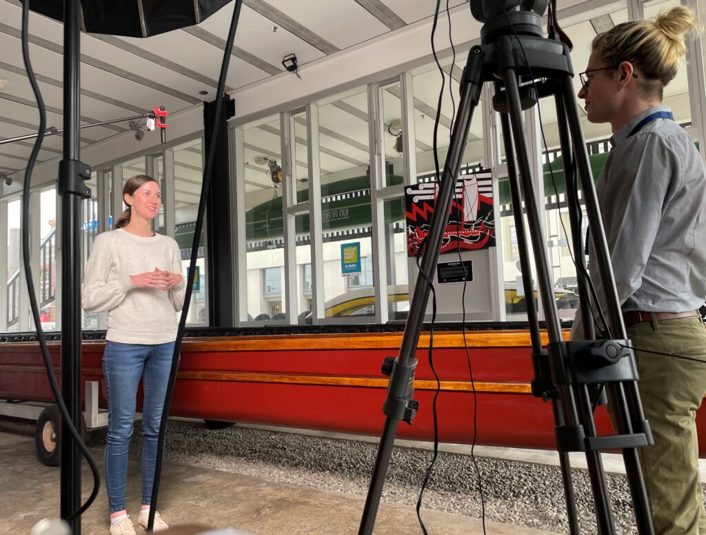 SAVVY express, delivered by the New Zealand Science Media Centre, is an opportunity for researchers to practise communicating about their work in a compelling way for a general audience.
Participants in SAVVY Express receive individual coaching to help them speak on camera about their research, and receive a polished 90-second video edited from their best takes during the session as an added bonus.
Our intent is for delegates to be given opportunity to prepare their own videos, which will be compiled into a video proceedings for publication.
- Presenter(s): Science Media Centre staff
- Proposed date: 30 April & 1 May
- Proposed time: 09:00-16:00
- Number of spaces: Series of 15 minute slots for individuals
Further details
You do not need to register for this during the conference registration process. Instead, we will be recommending this option for selected paper / abstract authors, and will direct you to the booking page to arrange your slot in the programme. The facilitators will be on site during the conference and taking attendees at the booked time.
Find out more about SAVVY express here: https://www.sciencemediacentre.co.nz/savvy-express/
Our training packages are still in development, and we welcome proposals from delegates to deliver training, or suggestions for training that delegates may wish to receive.